This is from the Storm Prediction Center in Norman OK.
AN UNSEASONABLY STRONG WEATHER SYSTEM CONTINUES TO EJECT OUT OF THE ROCKIES AND ACROSS THE NORTHERN AND CENTRAL PLAINS TODAY...WITH ASSOCIATED SURFACE LOW PRESSURE SYSTEM LIFTING ACROSS NORTHERN MINNESOTA. IN RESPONSE...VERY STRONG LOW LEVEL AND UPPER LEVEL WINDS WILL OVERSPREAD A LARGE PART OF THE MIDDLE U.S. AND SUPPORT EXTREMELY STRONG WIND SHEAR FOR THIS TIME OF YEAR. THIS WILL SET THE STAGE FOR A POSSIBLE OUTBREAK OF SEVERE THUNDERSTORMS ..INCLUDING TORNADOES THIS AFTERNOON AND TONIGHT. STRONG AND DAMAGING TORNADOES ALONG WITH WIDESPREAD WIND DAMAGE ARE EXPECTED IN THIS REGION. AS HEATING AND SURFACE MOISTURE INCREASE THROUGH THE MORNING AND EARLY AFTERNOON...THE ATMOSPHERE WILL BECOME MORE SUPPORTIVE OF THUNDERSTORMS DEVELOPING OVER PORTIONS OF CENTRAL MINNESOTA. SEVERE THUNDERSTORMS WILL BECOME MORE WIDESPREAD AND INTENSIFY QUICKLY THROUGH THE DAY ACROSS MUCH OF THE UPPER MISSISSIPPI RIVER VALLEY...WITH DEVELOPMENT OCCURRING SOUTH-SOUTHWESTWARD ALONG A SURFACE COLD FRONT ACROSS EASTERN IOWA AND POSSIBLY NORTHEASTERN MISSOURI BY LATE IN THE DAY. EXTREME SHEAR WILL SUPPORT SUPERCELLS AND FAST MOVING LINES OF THUNDERSTORMS ACROSS THIS REGION...WITH POTENTIAL FOR AN OUTBREAK OF TORNADOES AND DAMAGING WINDS AS STORMS RACE EAST-NORTHEASTWARD THROUGH THE EVENING INTO THE GREAT LAKES. LARGE HAIL WILL ALSO BE COMMON WITH THESE STORMS. THIS IS POTENTIALLY A VERY DANGEROUS SITUATION. THOSE IN THE THREATENED AREA ARE URGED TO REVIEW SEVERE WEATHER SAFETY RULES AND TO LISTEN TO RADIO...TELEVISION...AND NOAA WEATHER RADIO FOR POSSIBLE WATCHES...WARNINGS...AND STATEMENTS LATER TODAY.
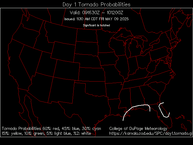
The Above map shows the probabilty of Tornadoes Today
This is a very dangerous situation, be sure to keep an eye to the Sky this afternoon and evening.
Well, I just got back from Greenbay, and now I am located right in the middle of the danger zone. I am a dumbass to keep this computer on, I know. Everything is very very humid right now, and the sky is a light yellow.
I will when everything ets worked up.
It looks like a normal day right now but, this wind won't be coming till a lil later. I will try taking a video of now, and after.
Storms always seem to avoid my area lately. I love severe storms, and I'm a little disappointed right now cause I've been looking forward to this all day. I really can't tell if it's going to hit my area or not. I agree with woodland though, never seems as amazing as they predict.
This storm system which was a very dynamic situation I might add with a powerful winter like cold front failed to break an upper level CAP.
A Cap is warm air aloft in the high levels of the atmospehere which sometimes inhibits Thunderstorm dynamics.
With that said, all the things where in place for a major Severe Weather/Tornado outbreak but in the end we can spend millions if not billions in sophiticated weather equipment but Mother Nature is ultimately going to do what it wants to do.
msoeagle wrote:I didn't realize this was weather.com
If you dont like our discussion then dont participate. Thank you
Not all the topics in this forum can be about your inability to select a cell phone.
Tell that to the other 5000 people that cant pick one, and at least we didn't end up buying a piece of crap. Anyways the d**n weather people said that it was going to be so bad AND IT DIDN'T EVEN RAIN!!!! Being a weather man/woman is the only job where you can be wrong over and over again and not get fired.
If you cannot contribute to the conversation, in a constructive matter, dont post.
Let me reitterate here....
With that said, all the things where in place for a major Severe Weather/Tornado outbreak but in the end we can spend millions if not billions in sophiticated weather equipment but Mother Nature is ultimately going to do what it wants to do.
well over here, the storm passed right through us, luckily no damage in iron mountain, but everywhere else, like crivits and esky. Bad bad damage. We got hit HARD with this. my parents and I had to take shelter int he basement. I recorded the ebs signal on the radio. I will have to somehome upload it from my camera and put it in a video format.
I just thought I would chime in a bit late on this. Basically everything that could have gone "wrong" (wrong in a sense to prohibit thunderstorm development) did go wrong.
First, that setup was one of the best I've seen in a very long time. It had the power of a winter system (where warm 80 degree temperatures clash with 20 degree temperatures over a distance of only a couple hundred miles), but this was in June. Winds were howling at over 100 mph just a couple thousand feet off the ground. Everyone thought there would be a unprecedented severe weather outbreak. The storm prediction center released a 'High Risk' which is only used once or twice annually, the national weather service in Chicago issued two live weather updates via weather radio to news outlets during the day, this had never been done. We were under a 'PDS Tornado Watch' the highest level of storm watch possible. Every forecaster around was gearing up for a huge squall line to form.. at the end of the night we were left scratching our heads.
So what happened?
Well, first of all, warmer than expected temperatures streaked north along the low level jet stream (the wind howling at 100 mph just a few thousand feet up). The air aloft was actually warmer than the air at the surface. What this did was serve as a 'cap' on the atmosphere, preventing air from rising rapidly. Second, our surface temperatures did not reach expected highs. At DeKalb, it was predicted to soar to at least 90 if not higher. We didn't break 86 that day. This was due in part to blow off clouds from smaller storms forming along the dry line. The dry line became detached from the cold front and served as a 'premature' trigger mechanism. Small storms, very few severe, formed along this line but with insufficient lift they died quick. They did, however, leave plenty of clouds that washed downstream keeping us cooler. Third, the cold front slowed down and the storm went farther north than expected. Instead of the cold front clashing with the warm juicy air in Iowa in mid afternoon, it didn't start to come through until after sunset. By this time, surface temperatures had cooled to the point that no severe storms were really going to form.
And on a side note, MSOeagle, I challenge you to try and forecast the weather, or try and do any forecasting at all. People get paid big money to forecast stocks, predict traffic, or hell.. even the score of a big football game. Nobody can predict the future, they never will be able to. There are just too many variables to try and piece together to come to a conclusion (I can show you come pretty complex weather maps and probably name off 50 variables that we have to process to come up with our predictions). Until you can do that, please, step off.