SFGAmWorld.com
Untitled Document
Park Information
Latest News
Great America
Roller Coasters
Rides
Hurricane Harbor
Water Slides
Water Attractions
Advertisement

Severe Weather likely This Afternoon & Sunday

A Off-Topic forum to discuss things that aren't related to the Amusement Park Industry.
Postby Galvan on March 11th, 2006, 1:37 pm
THIS PORTION OF THE HAZARDOUS WEATHER OUTLOOK IS FOR NORTH CENTRAL
AND NORTHEAST ILLINOIS...AND NORTHWEST INDIANA.

.DAY ONE... TODAY AND TONIGHT

THUNDERSTORMS ARE LIKELY TODAY AND TONIGHT. A SLIGHT RISK OF SEVERE
THUNDERSTORMS EXISTS THIS AFTERNOON AND EVENING. LARGE HAIL AND
DAMAGING WINDS ARE THE PRIMARY THREATS...ALTHOUGH AN ISOLATED
TORNADO IS ALSO POSSIBLE.

.DAYS TWO THROUGH SEVEN... SUNDAY THROUGH FRIDAY

SEVERE THUNDERSTORMS ARE EXPECTED TO REDEVELOP SUNDAY AFTERNOON AND
EVENING. A MODERATE RISK OF SEVERE THUNDERSTORMS EXISTS SOUTH OF
INTERSTATE 80...GENERALLY ALONG AND SOUTH OF A LINE FROM OTTAWA TO
MORRIS TO HEBRON...WHILE A SLIGHT RISK ENCOMPASSES THE REMAINDER OF
NORTHERN ILLINOIS AND NORTHWEST INDIANA.
Image
Galvan
Moderator

User avatar
 
Posts: 3639
Joined: June 30th, 2003, 1:23 am
Location: Montgomery,IL

Postby nalarrabee4752 on March 11th, 2006, 1:52 pm
I like thunderstorms
Green Light!!!!!!!!!!!
nalarrabee4752

User avatar
 
Posts: 211
Joined: January 30th, 2006, 12:00 am

Postby DejaVuGurl1203 on March 11th, 2006, 2:02 pm
Awesome. Can't wait. :D
DejaVuGurl1203

User avatar
 
Posts: 4181
Joined: December 28th, 2002, 8:35 pm
Location: Illinois

Postby FRD714 on March 11th, 2006, 5:50 pm
Fun.....

Ive seen 5 snakes today already and only got rid of 2 of them. I think its the weather that is making them come out.
Frank
FRD714

User avatar
 
Posts: 3547
Joined: October 26th, 2005, 4:46 pm
Location: Chicago

Postby Aero737 on March 11th, 2006, 6:13 pm
Mike, wern't you bragging about how you were going to spotter training today?
Aero737
The Mod Squad

User avatar
 
Posts: 3787
Joined: February 6th, 2003, 10:54 pm
Location: Beijing CHINA

Postby Galvan on March 12th, 2006, 2:09 am
Nope
Image
Galvan
Moderator

User avatar
 
Posts: 3639
Joined: June 30th, 2003, 1:23 am
Location: Montgomery,IL

Postby Galvan on March 12th, 2006, 5:39 am
Looking at some of the forecasts. Illinois and Misourri is in a high risk of Tornadoes today.

Image

Image

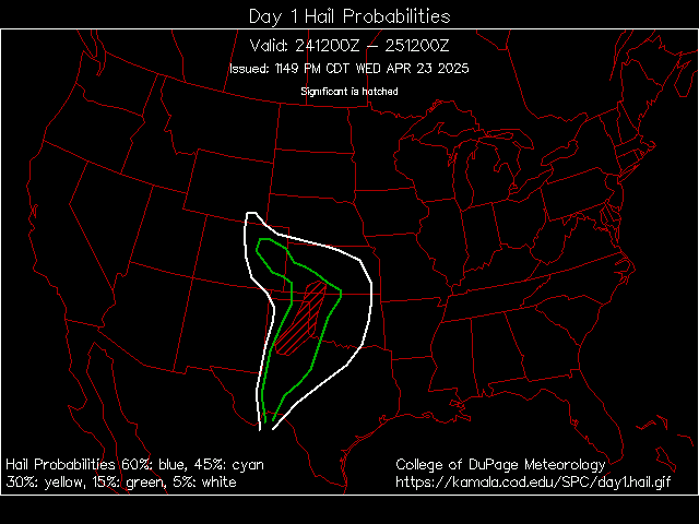
This image shows the probability of Hail.


It looks like its going to be a pretty rough day today.


...SEVERE THUNDERSTORM OUTBREAK EXPECTED OVER PARTS OF THE LOWER MISSOURI AND MID MISSISSIPPI RIVER VALLEYS LATER TODAY AND TONIGHT... THE NWS STORM PREDICTION CENTER IN NORMAN OK IS FORECASTING THE DEVELOPMENT OF A FEW STRONG...LONG-TRACK TORNADOES OVER PARTS OF THE LOWER MISSOURI AND MID MISSISSIPPI RIVER VALLEYS LATER TODAY AND TONIGHT. THE AREAS MOST LIKELY TO EXPERIENCE THIS ACTIVITY INCLUDE FAR SOUTHERN IOWA WEST CENTRAL ILLINOIS MISSOURI SURROUNDING THE HIGH RISK AREA...THERE IS A MODERATE RISK OF SEVERE THUNDERSTORMS FROM EASTERN OKLAHOMA AND KANSAS INTO THE MID SOUTH AND OHIO RIVER VALLEY. A VOLATILE SITUATION IS EXPECTED TO UNFOLD OVER EASTERN PORTIONS OF THE CENTRAL PLAINS AND MUCH OF THE LOWER MISSOURI...MID MISSISSIPPI AND OHIO RIVER VALLEYS TODAY AND TONIGHT. A VERY STRONG UPPER LEVEL STORM SYSTEM AND ASSOCIATED JET MAX WILL QUICKLY OVERSPREAD AN UNSEASONABLY WARM AND MOIST SURFACE AIR MASS THIS AFTERNOON. WE EXPECT THAT SEVERAL AREAS OF SIGNIFICANT SEVERE WEATHER WILL DEVELOP DURING THE PERIOD. THE MOST SIGNIFICANT OF WHICH MAY OCCUR OVER THE NORTHERN HALF OF MISSOURI/FAR SOUTHERN IOWA INTO WEST CENTRAL ILLINOIS AHEAD OF A STRENGTHENING LOW PRESSURE CENTER AND ITS ACCOMPANYING WARM FRONT. THIS ACTIVITY IS EXPECTED TO DEVELOP DURING THE EARLY TO MID AFTERNOON AND RACE EAST-NORTHEASTWARDS THROUGH THE EVENING IN THE FORM OF TORNADIC SUPERCELLS...MANY OF WHICH COULD BECOME QUITE STRONG AND LONG-LIVED. OTHER POTENTIALLY TORNADIC SUPERCELLS ARE EXPECTED TO DEVELOP LATE TODAY AND THIS EVENING ALONG A DRY LINE EXTENDING INTO FAR EASTERN OKLAHOMA AND NORTHEASTERN TEXAS. THESE WILL SPREAD A THREAT OF SEVERE WEATHER...INCLUDING DAMAGING TORNADOES...ACROSS ARKANSAS INTO THE MID SOUTH/LOWER OHIO RIVER VALLEY THROUGH THE NIGHT. THIS IS POTENTIALLY A VERY DANGEROUS SITUATION. THOSE IN THE THREATENED AREA ARE URGED TO REVIEW SEVERE WEATHER SAFETY RULES AND TO LISTEN TO RADIO...TELEVISION...AND NOAA WEATHER RADIO FOR POSSIBLE WATCHES...WARNINGS...AND STATEMENTS LATER TODAY.
Image
Galvan
Moderator

User avatar
 
Posts: 3639
Joined: June 30th, 2003, 1:23 am
Location: Montgomery,IL

Postby Aero737 on March 12th, 2006, 1:14 pm
Major Severe Outbreak today!
Aero737
The Mod Squad

User avatar
 
Posts: 3787
Joined: February 6th, 2003, 10:54 pm
Location: Beijing CHINA

Postby [jonrev] on March 12th, 2006, 1:29 pm
[jonrev]

User avatar
 
Posts: 3728
Images: 0
Joined: April 21st, 2003, 11:40 am
Location: Lake Wazzapamani

Postby FRD714 on March 12th, 2006, 2:56 pm
I wouldnt worry. For some reason, the cells always weaken when they get around the Chicago area. I always watch the weather channel, so I know that for a fact. But the storms arent too far from you, so I may be wrong today.
Frank
FRD714

User avatar
 
Posts: 3547
Joined: October 26th, 2005, 4:46 pm
Location: Chicago

Postby Aero737 on March 12th, 2006, 3:28 pm
^ You don't know what your talking about.
Aero737
The Mod Squad

User avatar
 
Posts: 3787
Joined: February 6th, 2003, 10:54 pm
Location: Beijing CHINA

Postby FRD714 on March 12th, 2006, 3:55 pm
Aero737 wrote:^ You don't know what your talking about.

lol....yea. :lol:
Frank
FRD714

User avatar
 
Posts: 3547
Joined: October 26th, 2005, 4:46 pm
Location: Chicago

Postby [jonrev] on March 12th, 2006, 4:04 pm
Some nasty storms heading straight for me! :o
[jonrev]

User avatar
 
Posts: 3728
Images: 0
Joined: April 21st, 2003, 11:40 am
Location: Lake Wazzapamani

Postby FRD714 on March 12th, 2006, 4:21 pm
^Ride the storm out....
Frank
FRD714

User avatar
 
Posts: 3547
Joined: October 26th, 2005, 4:46 pm
Location: Chicago

Postby Aero737 on March 12th, 2006, 9:38 pm
Springfield IL was just hit by a LARGE tornado...reports of damage coming in...One of the scariest looking storms i've seen
Aero737
The Mod Squad

User avatar
 
Posts: 3787
Joined: February 6th, 2003, 10:54 pm
Location: Beijing CHINA

Postby DejaVuGurl1203 on March 12th, 2006, 9:41 pm
Oh wow.. that sucks. There are tornado watches just south of me... I'm pretty darn close to them though.
DejaVuGurl1203

User avatar
 
Posts: 4181
Joined: December 28th, 2002, 8:35 pm
Location: Illinois

Postby [jonrev] on March 12th, 2006, 9:45 pm
[jonrev]

User avatar
 
Posts: 3728
Images: 0
Joined: April 21st, 2003, 11:40 am
Location: Lake Wazzapamani

Postby Galvan on March 12th, 2006, 10:43 pm
ONLINE LIVE NOAA RADIO LINK:

http://weather.admin.niu.edu/liveaudio/
Image
Galvan
Moderator

User avatar
 
Posts: 3639
Joined: June 30th, 2003, 1:23 am
Location: Montgomery,IL

Postby Galvan on March 12th, 2006, 10:58 pm
PDS TORNADO WATCH IN EFFECT UNTIL 4AM. This is a Particularly Dangerous Situation as a major tornado outbreak is possible in the effected areas tonight.
Image
Galvan
Moderator

User avatar
 
Posts: 3639
Joined: June 30th, 2003, 1:23 am
Location: Montgomery,IL

Postby FRD714 on March 12th, 2006, 11:30 pm
We need a weather forum on here.
Frank
FRD714

User avatar
 
Posts: 3547
Joined: October 26th, 2005, 4:46 pm
Location: Chicago

Postby DejaVuGurl1203 on March 12th, 2006, 11:36 pm
No we don't.
DejaVuGurl1203

User avatar
 
Posts: 4181
Joined: December 28th, 2002, 8:35 pm
Location: Illinois

Postby FRD714 on March 12th, 2006, 11:49 pm
^Ah...whatever. The storms are just missing me, but they will probably hit in the next few hours.
Frank
FRD714

User avatar
 
Posts: 3547
Joined: October 26th, 2005, 4:46 pm
Location: Chicago

Postby DejaVuGurl1203 on March 12th, 2006, 11:50 pm
Yeah, it's practically going around me too. We had one a while ago but it was nothing.
DejaVuGurl1203

User avatar
 
Posts: 4181
Joined: December 28th, 2002, 8:35 pm
Location: Illinois

Postby Aero737 on March 13th, 2006, 12:28 am
"SPRINGFIELD HAS BEEN HARD HIT. EVERY EXIT IN AND OUT OF THE CITY HAS BEEN BLOCKED OFF. SPRINGFIELD IS CLOSED." -- Springfield, IL state police
Aero737
The Mod Squad

User avatar
 
Posts: 3787
Joined: February 6th, 2003, 10:54 pm
Location: Beijing CHINA

Postby FRD714 on March 13th, 2006, 7:32 am
The storms werent bad at all. I thought it was going to get ugly, but it didnt. A little thunderstorm that went on and off for about an hour and that was it.
Frank
FRD714

User avatar
 
Posts: 3547
Joined: October 26th, 2005, 4:46 pm
Location: Chicago

Next

Return to Off-Topic Forum

Who is online

Users browsing this forum: No registered users and 17 guests

Privacy Policy About Us Copyright Disclaimer E-Mail SFGAmWorld
COPYRIGHT - SFGAmWorld.com
All content and images on this site are Copyright 2001 - SFGAmWorld.com and may not be used without permission.
This is NOT the official site of Six Flags Great America, SFGAmWorld.com is not affilated or endorsed by Six Flags Great America.
SFGAmWorld.com does not make any guarantee on the accuracy of the information on this website and cannot be held responsible by the use of this information.
SIX FLAGS and all related indicia are trademarks of Six Flags Theme Parks Inc. ®, TM and © . The official Six Flags site can be found at SixFlags.com
BATMAN, SUPERMAN and all related characters and elements are trademarks of © DC Comics.
LOONEY TUNES and all related characters and elements are trademarks of and © Warner Bros. Entertainment Inc.©
The Wiggles Pty Ltd. SCOOBY-DOO and all related characters and elements are trademarks of and © Hanna-Barbera.