|
||||||||||||||||||
|---|---|---|---|---|---|---|---|---|---|---|---|---|---|---|---|---|---|---|
|

|
Big severe weather day
41 posts
• Page 2 of 2 • 1, 2
aero are you majoring in meteorology by any chance? That's stuff is pretty cool.
1. Voyage
2. X 3. Millenium Force 4. Top Thrill Dragster 5. Raging Bull '05 Bull: 113 '06 Bull: lost count but not a lot

Any more chances for PREDICTIONS of Severe Weather, not like any will hit us, ever!
Yes, I'm majoring in meteorology.
This is the sounding at KDKB (DeKalb Airport) at 3pm around the time that the storms were flairing up. 
You have wind barbs on the right hand side of the graph (the look like a bunch of backwards L's) 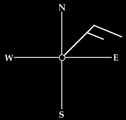
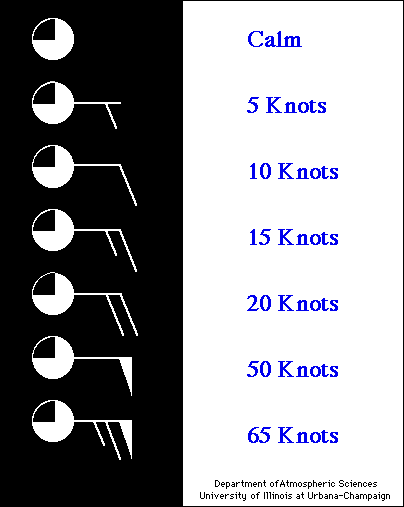
You can see that the winds from 1000 to about 5000 feet were only 5-10 knots. This means that there is very little wind shear (increase in wind speed and direction as you go higher in the atmosphere). Without windshear the precipatation will just fall right into the updraft (Warm moist air that gets sucked into the thunderstorm) thus cooling it. Also, the downward drag of the rain, brings down cold air from the upper atmosphere and futher slows the upward motion of air. What happens then, is the thunderstorm has no source of energy and collapses. You can think of a hot air balloon. You have the balloon filled empty and laying on the ground. You turn the fan on to start inflating it and at the same time you start the fire. This sends hot air into the balloon. This causes the balloon to rise into the atmosphere. If you turn off the fire, then the balloon looses bouyancy and begins to decend and finally collapses. When a thunderstorm collapses it will cause a great deal of cold air to spread out horisontally across the ground. This creates a gust front which will compleatly gut off the storm from any warm air (in most cases). This happened today and could be seen easily on radar. Storms in DeKalb county formed, and then collapsed. We had calm stagnet warm air here in Geneva (20 miles away) until the gust front hit. Then we had gusty west winds and temperatures dropped from the 90's into the mid 80's. And we're outlooked for severe weather the next 3 days, but I think the storms will be more of garden variety thunderstorms much like the ones the deep south gets.

As you can see in this 500mb plot (around 5,800 meters) we're cut off from the main jetstream that is in MN and WI.

I really wish I knew what that meant. Weather is cool. Go Meteorology!

Yep! It is hard to learn. Heck in terms of what I know atm, I'm still new at this. Aero: If I get anything wrong, please correct me. This is where I would usually put stuff. Can't think of anything right now... =/

The current out look basicly puts us in a moderate risk for severe weather today. From what it looks like, things will go downhill by this afternoon. The threats looks to be large hail, destructive winds(VERY LIKELY), and their is a 5% chance for tornadoes.
in my opinion, I think the greatest threat for tornadoes is back into Iowa and north central IL. Now, I dunno if I'm right about that or not but I just got a feeling that is where the greatest risk is. In that area a isolated strong tornado(F3 or higher.) is possible, which is why their in the 15% catagory. Aero: Get in here and give us your analysis on all this. Btw, if you guys have not noticed, the outlook in Aero's 1st post updates itself so that outlook will always be up to date. Edit: For a more detailed outlook, go here: http://wxcenter.wxchat.com/index.php?fo ... maps&day=1 This is where I would usually put stuff. Can't think of anything right now... =/
I have to agree with that.
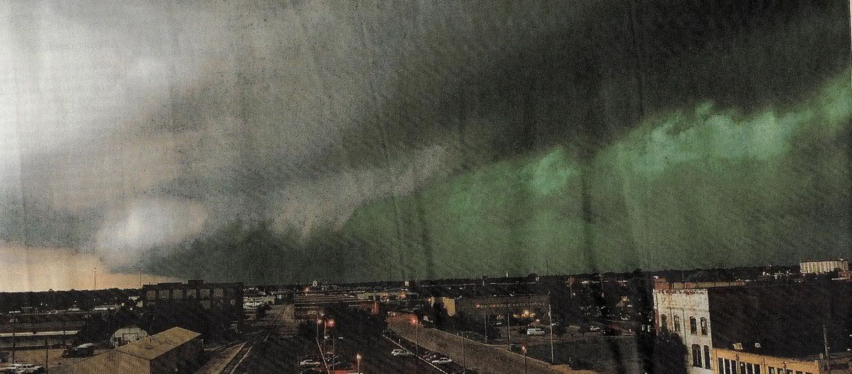
Yeah, I agree. That is one awesome photo!
That picture is screaming run away.
Top 5 wood-5-Goliath 4-Ravine Flyer II 3-Phoenix 2-Voyage 1-El Toro
Top 5 Steel- 5-Velocicoaster 4- Maverick 3- Fury 325 2-Steel Vengeance 1-X2 Coaster Count: 444

Alright (cracks knuckles) I've been so cought up playing battlefield 2 I didn't even know I was outlooked for severe thunderstorms !!! I know...
Anyways. Analysis for Today 6-13 RUC Model shows a good ridge of instability from Texas along the mississippi valley to the upper great lakes. Thunderstorms this morning were along a secondary warm front. Behind the front skies are clearing rapidly. Dewpoints are approaching 70 in some locations that recieved rain this morning. BUFKIT data is suggesting that CAPE (Energy) values will be around 1400 J/kg (joules of energy per kilogram of air). Also, helicity will be around 135 (helicity is the turn in winds within the first 3km of the atmosphere-good for assessment of possible tornadic thunderstorms) which is enough for isolated supercells. Temperatures today should reach the 90 degree mark with high dewpoints so instability numbers may be underestimated by the models. Inscreasing mid and low level winds will help any thunderstorms that develop quickly become severe. I'm waiting for the 18 z (1pm) sounding from Davenport and Lincoln Illinois to get a bit more data. As it looks now, Winds will definatly be a problem with these storms with isolated supercells (possible tornadoes) and large hail a secondary threat.
Looks like some severe weather could head are way tommarow. Aero what is your prediction?
I don't think rainfall is going to be anything substantial, at least anything that will needed to put somewhat of a dent in the drought. This is where I would usually put stuff. Can't think of anything right now... =/
I'm bored...I'll do a writeup for tonight and tommrow..Let me type it up.
Well, First we'll start with the Current Conditions.

Current Mesoscale discussion relating to the area of increasing convection moving over the Mississippi river at the moment. 
Without Daytime heating it's going to be tough for these storms to go severe. The CAPE (energy) field extends up the Mississippi River near the Illinois/Iowa/Wisconsin border. SB/CAPE values are generally in the 1500 J/KG range (minimally unstable). Current MU/CAPE (Most Usable Energy) is MUCH higher (around 2500-3000 which is high instability) although that cape is not surface based and is above the inversion. Helicity Values along and north of the Warm Front are currently in the 300 m²/s² range which suggests that there is favorable directional shear if convection was to form for isolated tornados...however convection is not expected the the areas of high helicity so tornado threat is negliable. 
Helicity Plot at 11pm CDT TOMMROW As it stands now, it's not looking good for severe weather tommrow. 
This is a 7am plot of CAPE (energy). This is a plot of the 7pm surface map. 
In GP terms here Aero. I'm going upnorth all weekend, am I going to need a basement?
Top 5 wood-5-Goliath 4-Ravine Flyer II 3-Phoenix 2-Voyage 1-El Toro
Top 5 Steel- 5-Velocicoaster 4- Maverick 3- Fury 325 2-Steel Vengeance 1-X2 Coaster Count: 444
Hail threat??

41 posts
• Page 2 of 2 • 1, 2
Who is onlineUsers browsing this forum: No registered users and 21 guests
| ||||||||||||||||||||||||||||||||||||||||||||||||||||||||||||