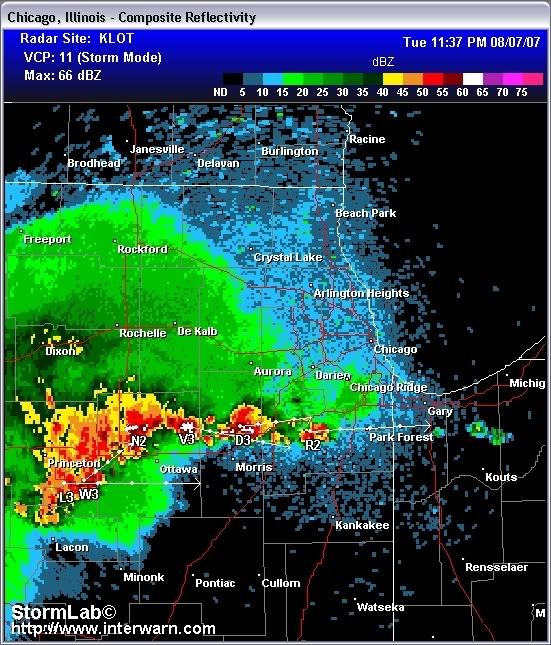
Good evening, and I am watching a series of Strong to Severe Storms heading into our area, below you can see Doppler Radar as of around 650 a line of pretty nasty storms in the Aurora area as well as a nasty looking cell around Rochelle.
These storms are a result of the weak frontal system that is impacting our area from the North, as you see below. This front as it impacts our area which has been in a very humid practically all weekend and Today...
Sets the stage for the likelyhood of Strong to Severe Weather Tonight.
The result for these storms could be locally heavy rain of 2 to 4 inches as well as damaging winds and hail.
Already the National Weather Service has issued a Flood Watch
FLASH FLOOD WATCH FOR PORTIONS OF ILLINOIS AND NORTHWEST
INDIANA...INCLUDING THE FOLLOWING AREAS...IN ILLINOIS...
BOONE...COOK...DE KALB...DUPAGE...GRUNDY...KANE...KENDALL...LA
SALLE...LAKE ILLINOIS...LEE...MCHENRY...OGLE...WILL AND
WINNEBAGO. IN NORTHWEST INDIANA...LAKE INDIANA AND PORTER
As always, Any breaking weather info will be posted As soon as possible, any other questions IM me on AIM by clicking the AIM button below.
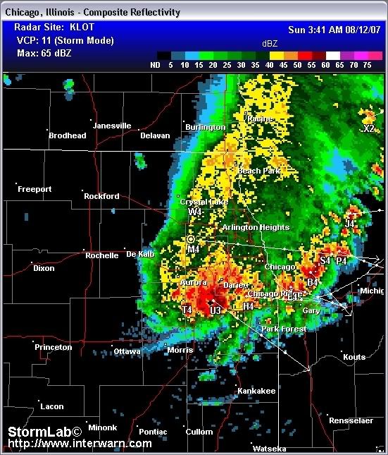
THE NATIONAL WEATHER SERVICE IN CHICAGO HAS ISSUED A
* SEVERE THUNDERSTORM WARNING FOR...
NORTHERN COOK COUNTY IN NORTHEAST ILLINOIS...
DUPAGE COUNTY IN NORTHEAST ILLINOIS...
NORTHERN KANE COUNTY IN NORTHEAST ILLINOIS...
* UNTIL 345 AM CDT...
* AT 245 AM CDT...NATIONAL WEATHER SERVICE RADAR INDICATED A SEVERE
THUNDERSTORM LOCATED NEAR HAMPSHIRE...AND MOVING SOUTHEAST AT 35 MPH.
THIS STORM IS CAPABLE OF PRODUCING DAMAGING WINDS 60 TO 70 MPH...
WHICH CAN KNOCK DOWN LIMBS AND POWER LINES.
* THE SEVERE THUNDERSTORM WILL BE NEAR...
SLEEPY HOLLOW BY 255 AM...
ELGIN...WEST DUNDEE...EAST DUNDEE...AND CARPENTERSVILLE BY 300
AM...
STREAMWOOD...BARTLETT...AND HOFFMAN ESTATES BY 310 AM...
HANOVER PARK...AND SCHAUMBURG BY 315 AM...
IN ADDITION...VERY HEAVY RAINFALL WILL ACCOMPANY THESE STORMS WHICH
MAY LEAD TO FLOODING.
It's horrible where I am. Granted I live on the top of the tallest hill in my county and I get the worst of it, it's still lightninging every few seconds.
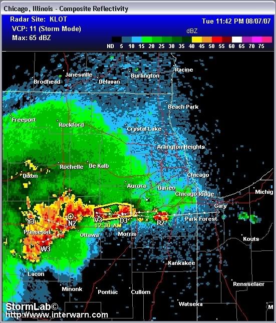
Another line of Showers and Thunderstorms expected to impact our area tonight.. And With that a Severe Thunderstorm Warning has just been issued
THE NATIONAL WEATHER SERVICE IN CHICAGO HAS ISSUED A
* SEVERE THUNDERSTORM WARNING FOR...
NORTHEASTERN LA SALLE COUNTY IN NORTH CENTRAL ILLINOIS...
SOUTHERN KENDALL COUNTY IN NORTHEAST ILLINOIS...
* UNTIL 1230 AM CDT...
* AT 1142 PM CDT...NATIONAL WEATHER SERVICE RADAR INDICATED A SEVERE
THUNDERSTORM LOCATED NEAR NEWARK...AND MOVING EAST AT 10 MPH. THIS
STORM IS CAPABLE OF PRODUCING DAMAGING WINDS IN EXCESS OF 60 MPH.
* THE SEVERE THUNDERSTORM WILL BE NEAR...
NEWARK BY 1205 AM...
A line of strong storms is coming straight at us from Wisconsin. This storm is capable of heavy winds and has a history of producing mesocyclones. Be careful tonight.
Already have the strong winds here. Weather Underground's radar was showing a mesocyclone near Round Lake Beach and just north of Grayslake a few minutes ago.
We have got a pretty interesting line going here.... Taking a look at the Doppler pretty nice looking cell In Central Dupage and West Central Cook, this storm is moving south and has a history of producing Heavy Rains and Winds up to 60 MPH.
Omg, a strong thunderstorm just passed. It woke me up before it got bad. The thunder got louder and louder, and finally, the lightning was right next to us. This is my least favorite part when I'm trying to sleep, but still exciting. As my anxiety rose to a certain point, it got crazy. All of a sudden there was another bolt of lightning that sounded and looked like it hit something. Either our house, the fence, or a tree or something. The power went on and off and on a bit, and a car alarm went off. That was scary. The lightning was absolutely crazy. And I'm left wanting more...
My house shook last night from the thunder...my mom said I didn't get up during the storm which scared her because I usually never sleep through thunderstorms but the last couple of weeks when we've had bad storms....i've slept through them.
I jsut realized, gam must have a pretty good drain system or else it'd be quite flooded in a lot of areas. SFGAm is built, first of all, in a low spot of gurnee, and there are even lower parts in the park! Yukon and SWT mainly.