
Looking at the 00Z ETA.... It looks like there might be a chance of Severe Weather across Illinois tomorrow
The wind fields look rather nice. Granted the instability is rather
weak...only around 750 CAPE...somewhere in the mid afternoon....it is possible
for 1000 CAPES if a few things happen. Certainly the ETA breaks out a
great deal of precipitation.
Looks like we should see warm frontogenesis with mid 50 dew points
already in Southern IL.
|
||||||||||||||||||
|---|---|---|---|---|---|---|---|---|---|---|---|---|---|---|---|---|---|---|
|
|
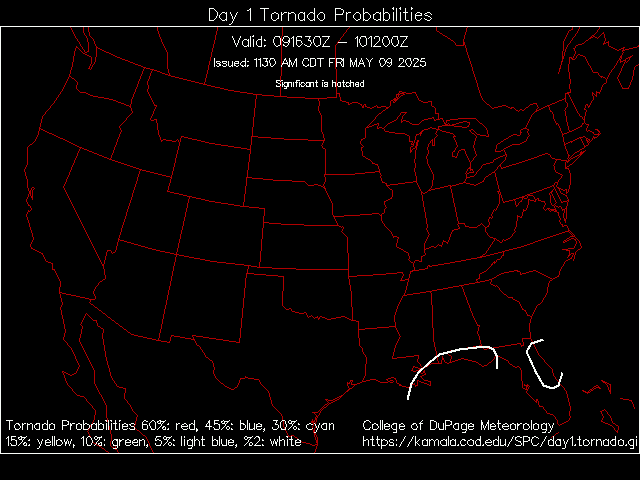
More Severe Weather Possible Today 11/8/05
56 posts
• Page 1 of 3 • 1, 2, 3
Last edited by Galvan on November 8th, 2005, 12:24 pm, edited 1 time in total.


I've got rain, thunder & lightning, plus its still sunny. This is on the south side of Springfield.
It's the most fun in the park when your laughing in the dark.

Just cloudy here in chicago, but it says stong and severe storms possiblr later in the day that will cause damaging winds. There is a 70% chance.
Frank
They're calling ISOLATED TORNADOES in the Midwest area!!
It's just rain and thunder in Grayslake right now. Some nasty stuff coming later though. ¯\_(ツ)_/¯ ...it's just a ride

It was raining buckets about a half hour ago. Then it slowed up to almost no rain, now it's back to raining pretty hard, but not as hard as it was earlier.
SPECIAL WEATHER ANNOUCEMENT:
There is a slight risk for tornadoes associated with this storm system as well. Thankfully, Its November... with this set up if it was April or June... wow!
CONCERNING...SEVERE THUNDERSTORM POTENTIAL VALID 051821Z - 052045Z TSTMS SHOULD DEVELOP AND INCREASE IN COVERAGE IN A BAND FROM NRN MO/SRN IA NEWD ACROSS NRN IL/SRN WI OVER THE NEXT FEW HOURS. A COUPLE OF STORMS COULD BECOME SEVERE AND PRODUCE HAIL. A WATCH IS NOT IMMINENT BUT TRENDS WILL CONTINUE TO BE MONITORED. AN INCREASE IN CONVECTION APPEARS LIKELY OVER THE NEXT 1-2 HOURS AS A LEAD IMPULSE NOW MOVING TOWARD NWRN MO FROM NERN KS ENHANCES DEEP LAYER ASCENT ACROSS A WARM FRONT ROUGHLY SITUATED FROM IRK TO GBG TO MDW. WHILE THIS LEAD IMPULSE IS WELL AHEAD OF A STRONGER SHORT WAVE TROUGH MOVING INTO THE CNTRL HIGH PLAINS... SUFFICIENT LIFT AND ELEVATED DESTABILIZATION ARE EXPECTED AND SHOULD SUPPORT AT LEAST A MARGINAL SEVERE HAIL THREAT DEVELOPING OVER THE NEXT FEW HOURS. LATEST DVN SOUNDING AT 18Z FURTHER SUPPORTS THIS SCENARIO WITH MID LEVEL LAPSE RATES AND EFFECTIVE SHEAR BOTH INCREASING SINCE 12Z. SHORT-TERM MODEL GUIDANCE ALSO INDICATES A GOOD PROBABILITY OF PRIMARILY ELEVATED TSTMS INCREASING NEAR AND NORTH OF THE WARM FRONT THROUGH 21Z.
So far it is just really cloudy and hazy over hear at UIC chicago. It doesn't even look like it has rained yet.
RIP: Trailblazer and Deja Vu...heck, even Alien Encounter
Fangs Up Cobra Style!!! Chitown's finest resident here!!!!!
In richfield wisconsin its thundering and is really windy.

It is now very dark and rainy at UIC.
RIP: Trailblazer and Deja Vu...heck, even Alien Encounter
Fangs Up Cobra Style!!! Chitown's finest resident here!!!!!
^
Zing 1 for Galvan RIP: Trailblazer and Deja Vu...heck, even Alien Encounter
Fangs Up Cobra Style!!! Chitown's finest resident here!!!!!
Tornado Watch for me down here in Peoria!!
"The world of politics is filled with uncivilized, snarling, rapacious beasts that, like untrained mutts, raise their legs and urinate on everything we hold dear," - Michael Savage
^ Rarely do we get watches and warnings up here, but theres always that chance. Its fine right now, but radar shows something nasty coming.
Frank
SPECIAL WEATHER ANNOUCEMENT:
URGENT - IMMEDIATE BROADCAST REQUESTED TORNADO WATCH NUMBER 841 NWS STORM PREDICTION CENTER NORMAN OK 350 PM CST SAT NOV 5 2005 THE NWS STORM PREDICTION CENTER HAS ISSUED A TORNADO WATCH FOR PORTIONS OF WESTERN AND PART OF CENTRAL ILLINOIS CENTRAL AND EASTERN MISSOURI EFFECTIVE THIS SATURDAY AFTERNOON AND EVENING FROM 350 PM UNTIL 1000 PM CST. TORNADOES...HAIL TO 2 INCHES IN DIAMETER...THUNDERSTORM WIND GUSTS TO 70 MPH...AND DANGEROUS LIGHTNING ARE POSSIBLE IN THESE AREAS. THE TORNADO WATCH AREA IS APPROXIMATELY ALONG AND 85 STATUTE MILES EAST AND WEST OF A LINE FROM 30 MILES SOUTHWEST OF VICHY MISSOURI TO 55 MILES NORTH NORTHEAST OF QUINCY ILLINOIS. FOR A COMPLETE DEPICTION OF THE WATCH SEE THE ASSOCIATED WATCH OUTLINE UPDATE (WOUS64 KWNS WOU1). REMEMBER...A TORNADO WATCH MEANS CONDITIONS ARE FAVORABLE FOR TORNADOES AND SEVERE THUNDERSTORMS IN AND CLOSE TO THE WATCH AREA. PERSONS IN THESE AREAS SHOULD BE ON THE LOOKOUT FOR THREATENING WEATHER CONDITIONS AND LISTEN FOR LATER STATEMENTS AND POSSIBLE WARNINGS. DISCUSSION...POTENT SHORTWAVE TROUGH NOW MOVING ACROSS KS WILL LIKELY SUPPORT INCREASED SEVERE THUNDERSTORMS OVER WW THIS EVENING AS AIR MASS REMAINS MARGINAL TO MODERATELY UNSTABLE. INITIATION WILL LIKELY OCCUR NEAR LOW CENTER EXPECTED TO DEEPEN INTO NERN MO THIS EVENING AND NEAR EWD MOVING SURFACE COLD FRONT. PRIMARY SEVERE THREATS WILL BE DAMAGING WINDS AND LARGE HAIL AS STORMS EVOLVE INTO A SQUALL LINE. HOWEVER...SIGNIFICANT SHEAR AND BACKED SURFACE WINDS NEAR THE LOW CENTER WILL ALSO SUPPORT A THREAT OF A FEW TORNADOES WITH ANY SUPERCELLS/LEWP STRUCTURES. AVIATION...TORNADOES AND A FEW SEVERE THUNDERSTORMS WITH HAIL SURFACE AND ALOFT TO 2 INCHES. EXTREME TURBULENCE AND SURFACE WIND GUSTS TO 60 KNOTS. A FEW CUMULONIMBI WITH MAXIMUM TOPS TO 500. MEAN STORM MOTION VECTOR 25035. ...EVANS
all i heard earlier was thunder. Now there's nothing http://themeparkcritic.com/scripts/profile/ViewProfile.asp?ViewID=2909
A furious storm once roared `cross the sea, catching ships in its path, helpless to flee. Instead of a certain and watery doom, the winds swept them here to Typhoon Lagoon! *****Are you ready to Rockit?!*****

^ Do you live around rosemont?
Thanks for the special weather updates Galvan316! Frank
Severe T-storms on the way down here in Springfield. We have decent lightning, radar doesn't look too good, and my power already blinked once (usually an indication of high static discharge along the circuit).
Yet here I am still on the good ole net. It's the most fun in the park when your laughing in the dark.
Here in Peoria, VERY intense lightning, strong thunder, heavy rain, yet
NO WIND!!! Conditions for a possible tornado for me! Next all I need is hail! "The world of politics is filled with uncivilized, snarling, rapacious beasts that, like untrained mutts, raise their legs and urinate on everything we hold dear," - Michael Savage

This is a live Doppler Radar out of Lincoln amazingly powerful storms for November. (Note this image may change over time)
The lightning and thunder is starting to get bad here.
Frank
Pontiac's in the direct center of the orange in that pic. I can attest to the fact that it is very bad here.
'' If u commited suicide, u wouldn't be here anymore'' - Gangsta Fruit

56 posts
• Page 1 of 3 • 1, 2, 3
Who is onlineUsers browsing this forum: No registered users and 38 guests
| ||||||||||||||||||||||||||||||||||||||||||||||||||||||||||||||||||||||
