A storm system across the western United States will approach northern Illinois and northwest Indiana on Thursday. Rain, along with embedded thunderstorms will overspread northern Illinois and northwest Indiana Thursday morning, with a potential of heavy rain during the day. By late Thursday afternoon into Thursday evening, the threat of severe weather will also increase with a continued potential for heavy rain through Thursday night. Total rainfall amounts of 1 to 3 inches are expected from Thursday morning through Thursday night, with a potential for locally higher amounts. A flash flood watch is also in effect Thursday morning through late Thursday night for northern Illinois and northwest Indiana.
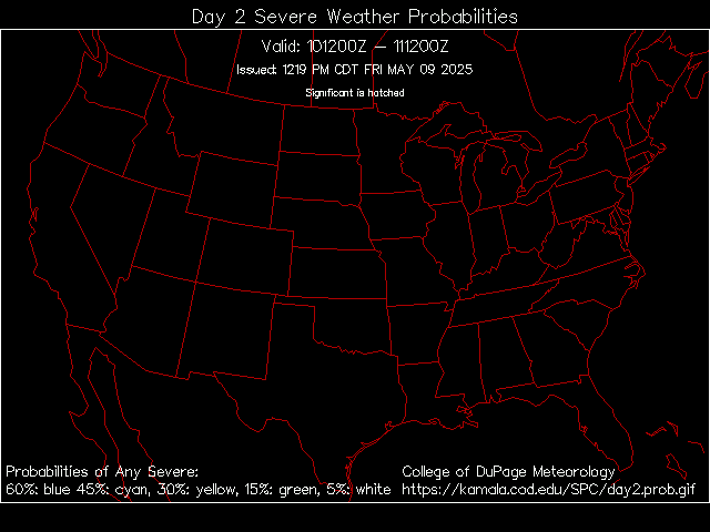
Below is a map of the effected area, So pretty much from Chicago to the Gulf Coast, a significant Severe Weather/Tornado outbreak is expected. (THIS MAP WILL CHANGE THROUGHOUT THE DAY)
I will monitor the situation and bring you updates as soon as they become available, Also, watch this forum for Severe Weather alerts like this all Season long.
I had to walk home from school in the downpour this afternoon.
Then the winds picked up and I had to chase my car cover I had on my Fiero 20 feet down my street (still downpouring). I finally threw that worthless piece of crap out once I caught it wrapped around a stop sign.